


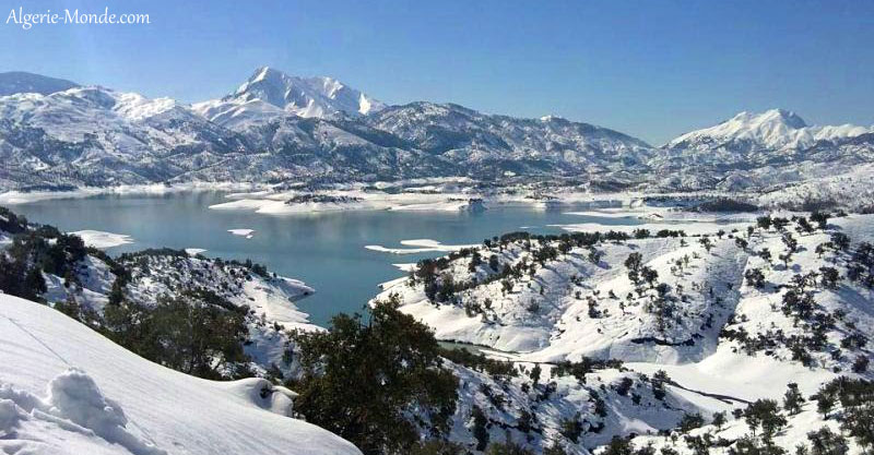
Taza lies in Jijel Province and the Guerrouche massif. This guide brings together the reliable facts needed to understand its landscape, protected status and the checks worth making before a visit.
Key facts
| Status | National park |
|---|---|
| Location | Jijel Province and the Guerrouche massif |
| Established | 1984 |
| Published area | 3,807 ha for the terrestrial core |
| Recognition | UNESCO Biosphere Reserve since 2004 |
| Main base | Jijel |
Understanding the protected area
Taza is not a single viewpoint or short walk. The protected area brings together Guerrouche forest, caves, cliffs and chasms, beaches and corniche and mountain streams and wadis, and changes in height, water and exposure shape what visitors see across the site.
Boundaries, legal names and published areas have changed over time. This page therefore uses the current reference material issued by Algeria’s Directorate-General of Forests, the Ministry of Culture or UNESCO, depending on the park, rather than repeating conflicting historical figures.
The protected area was established in 1984. Its designation includes UNESCO Biosphere Reserve since 2004.
The published reference area is 3,807 ha for the terrestrial core.
Landscapes and viewpoints
The best way to read this landscape is to follow the transition between habitats. The principal settings are Guerrouche forest, caves, cliffs and chasms, beaches and corniche and mountain streams and wadis. They affect the available routes, the quality of viewpoints and how quickly soil or vegetation can be damaged by heavy footfall.
Frequently cited landmarks include Guerrouche, Mount Koudiet El Kern (1,121 m), Taza valley, Dar El Oued valley and coastal caves and cliffs. Some are natural features, while others are heritage sites or practical orientation points. Access, road conditions and temporary closures should be confirmed locally rather than inferred from an old map.
Plants and wildlife
Plants and wildlife change with altitude, water and exposure. Regularly documented elements include zeen oak, Afarès oak, cork oak, Barbary macaque, wild boar and coastal birds. The list explains the habitats a visitor may pass through, but it is not a promise that a particular animal will appear.
Watch wildlife quietly and from a distance. Feeding or chasing animals for a photograph changes their behaviour and can place both visitors and animals at risk. In forest areas, fire, wind, snow or restoration work may also close a route at short notice.
Heritage and places to see
Although nature protection is central, the park also contains a human landscape. Paths, water points, seasonal use and older settlements connect environmental history with local life. Archaeological and historic places need the same care as fragile habitats.
Taza links the Guerrouche forest with valleys, caves and the cliffs of the Jijel coast. The continuity between land and sea explains the importance of its marine zone and its range of protected habitats. Historical photographs appear in the relevant sections so that each image remains connected to the place and subject it records.
Planning a visit
Jijel is the main base named in this guide. Before leaving, confirm road conditions, areas currently open to visitors, weather, seasonal restrictions and whether a guide or permit is required for the intended sector.
Wetlands and coastal habitats are easily disturbed. Stay on permitted approaches, keep away from birds and do not enter reed beds or nesting areas.
Wind, rain, local flooding and sea conditions can change the day. Binoculars are often more useful than trying to get close to wildlife.
Do not rely on archived opening times or prices. Park offices, local tourism services and relevant authorities are the right sources for operational details. Carry suitable water and clothing, leave time for delays and plan to finish before darkness.
Visit without damaging the site
A good visit leaves no new mark. These basic rules matter in forests, wetlands, exposed mountains, desert surfaces and archaeological areas alike.
- Stay on authorised paths and access routes.
- Carry every item of litter out, including food waste.
- Light no fires and respect seasonal restrictions.
- Do not feed wildlife; watch from a calm distance.
- Do not touch rock art, ruins, plants or geological features.
- Use authorised local guides and services where the terrain calls for them.
Taza rewards preparation that matches the terrain. Check the official sources, confirm conditions locally and keep the day flexible enough to turn back when weather, roads or conservation rules require it.
Practical questions
Where is Taza?
Taza is in Jijel Province and the Guerrouche massif. Jijel is the main base named here, but the exact approach should be confirmed for the season and any current restrictions.
What can visitors see?
The principal landmarks include Guerrouche, Mount Koudiet El Kern (1,121 m), Taza valley, Dar El Oued valley and coastal caves and cliffs. The wider landscape also includes Guerrouche forest, caves, cliffs and chasms, beaches and corniche and mountain streams and wadis, with plants and wildlife adapted to those habitats.
Can the park be visited without a guide?
That depends on the sector. Some approaches near towns are straightforward, while desert routes, border areas, caves and isolated mountain terrain may require a guide and formal permission. Confirm locally before setting out.
When is the best time to visit?
There is no single answer for the whole protected area. Heat, snow, rainfall, wind, fire risk and road conditions should be checked shortly before the planned visit.
Official sources and verification
The sources below support the status, area and principal characteristics used in this guide. Opening hours, fees, closures and access conditions must still be checked with the competent local authorities shortly before travel.