


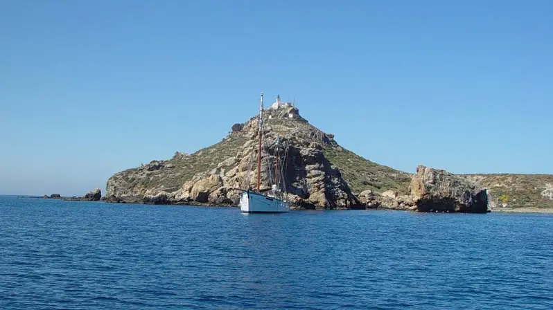
Off the wild Madagh coast west of Oran, the Habibas Islands rise as a compact world of volcanic cliffs, nesting birds and remarkably varied seabed. This is a protected archipelago, not a casual beach stop: understanding the rules, the sea and the ecological stakes is part of understanding the place.
Habibas at a glance
- Setting
- Western Algeria, opposite Madagh and Cap Blanc, west of Oran.
- Islands
- Two principal islands, western Gharbia and eastern Charguia, with smaller islets and rocks.
- Scale
- About 40 hectares of land; Gharbia is roughly 1.3 km long and reaches 105 m.
- Protection
- Marine nature reserve since 2003 and a Mediterranean SPAMI since 2005.
- Landmark
- An active lighthouse built in 1879 on Gharbia’s summit.
- Manager
- Algeria’s Commissariat National du Littoral, working with the maritime authorities.
Where the islands really are
Habibas belongs to the Oran coastal territory, but it is not immediately outside Oran harbour. The archipelago lies opposite the much wilder Madagh and Cap Blanc sector. SPA/RAC places the nearest mainland point at Madagh II, about 5.8 nautical miles away—just under 11 km. Bouzedjar is around 10 nautical miles from the islands, while Oran is roughly 26 nautical miles to the east.
The distinction matters when planning a trip. “Near Oran” describes the wider region, not a short hop from the city waterfront. On clear days the islands can be picked out from the Madagh coast. Their approximate bounds run from 35°42′47″ to 35°44′04″ north and 1°06′55″ to 1°08′50″ west.
Gharbia, Charguia and a coast cut into coves
Gharbia, the western island, is the larger of the pair. It stretches for about 1,300 metres and rises to 105 metres beneath the lighthouse. Charguia is rounder, smaller and about 55 metres high. A channel separates them, and a close scatter of peaks, reefs and rocks gives the group its cradle-like outline when seen from the mainland.
Three names recur in specialist descriptions: Fishermen’s Cove, the Bay of the Dead and the Bay of the Nymphs. The modest landing place is in the most sheltered part of the coast, beside a tiny strand. Habibas does not have the long, serviced beaches suggested by some social-media images. Much of the shore is rock, and some cliffs—especially around the Bay of the Dead—are friable and actively eroding.
The islands are volcanic. Dark dacites dominate the north; lighter rhyolites appear in the south, with greenish gypsum-bearing marls between them. Below the surface, rock predominates in shallow water and depths can fall away sharply, particularly on the western side. The resulting walls, passages and caves create valuable habitat, but also demand expert navigation.
A fishing refuge that became a marine reserve
The CNL management plan mentions reports of prehistoric activity but finds too little evidence to describe settled occupation before the early nineteenth century. It also records a local legend in which a Moorish man and a Spanish woman gave the islands their romantic name, with the woman said to have been buried there. It is best enjoyed as folklore rather than treated as established history.
For generations the islands served as a stop and seasonal base for Algerian, Spanish and French fishers. Small huts grew up near Fishermen’s Cove, some dating from the 1920s or 1930s. There was never enough fresh water or secure shelter for a substantial permanent community. Derelict cabins were removed in 2012 as part of work to restore the cove’s natural character.
Executive Decree 03-147 designated Habibas a marine nature reserve in 2003. It joined the Specially Protected Areas of Mediterranean Importance list in 2005 under the Barcelona Convention system. The protected envelope contains roughly 2,684 hectares of sea around 40 hectares of island land. A management plan adopted in 2013 set out conservation, monitoring, habitat restoration and tightly controlled public use.
The 1879 lighthouse and the people who kept it
The lighthouse has stood at the top of Gharbia since 1879. The management plan describes a 12-metre circular tower on a keeper’s house, with the light about 112 metres above sea level. The station was refurbished in 1975 and its electrical equipment modernised in 1992. It remains an operational aid to navigation managed by the ONSM, not a visitor attraction that can be assumed open.
An old track climbs from the landing cove through low, wind-shaped vegetation. Unofficial shortcuts have cut erosion channels into the slope, which is why staying on authorised paths is more than a matter of etiquette. There is virtually no tree cover and little dependable shade.
PIM Atlas preserves the story of Nordine, a lighthouse keeper who spent 22 years on Habibas. He described sweeping the roof terrace so that rainwater could be collected, making daily rounds and tending the light at night. Before automation, its mechanism had to be wound repeatedly. His memories also include crews and visitors stranded by sudden rough seas—a useful warning against treating the crossing as a routine sightseeing cruise.
When Cousteau’s Calypso called in 1977
Jacques-Yves Cousteau’s Calypso stopped at Habibas in August 1977. According to PIM Atlas, Cousteau was astonished by an underwater landscape whose richness was already becoming unusual in the Mediterranean. Marine biologist Jean-Georges Harmelin photographed a monk seal during the expedition.
The anecdote should not be turned into a wildlife promise. Monk seals continued to use Habibas into the early 1990s, but the management plan records their local disappearance. The 1977 encounter is valuable because it captures both the former abundance of the site and the reason its recovery matters.
Plants that survive salt, drought and wind
SPA/RAC lists 97 terrestrial plant species, nine of them endemic to North Africa. Most vegetation remains low and compact. Shrub communities including Salsola oppositifolia, Lycium intricatum, Frankenia corymbosa and Ephedra altissima mingle with short grassland and cliff plants.
The greenery is tougher than it looks but easy to damage. Trampling loosens thin soils, heavy gull concentrations alter them, and introduced plants can displace the original flora. Visitors should keep to the permitted track, take no cuttings and bring no pets, seeds or soil ashore.
A breeding refuge on a major migration route
Habibas is important for nesting seabirds and for migrants crossing the western Mediterranean. Audouin’s gull, Scopoli’s shearwater, Eleonora’s falcon and the Mediterranean shag are among its signature species. Ospreys, peregrine falcons, little egrets, rock doves and a wide variety of passing songbirds have also been recorded.
Historic survey figures reveal scale but should not be read as present-day censuses. Work summarised in the 2013 plan estimated roughly 400–500 breeding pairs of Scopoli’s shearwater and repeatedly found about 30 pairs of Eleonora’s falcon during surveys in the 2000s. Audouin’s gull numbers, by contrast, shifted dramatically between field seasons, illustrating how vulnerable a colony can be.
Black rats prey on eggs and chicks. Large numbers of yellow-legged gulls compete for space and change soil chemistry. Noise after dark, a dog brought ashore or a close approach to a nest adds avoidable pressure. From spring into autumn, distance and quiet are particularly important.
The habitats below the waterline
More than 900 hectares of hard substrate have been mapped, including about 100 hectares of coralligenous habitat and over 300 hectares of maerl beds. These slow-growing calcareous communities support a dense fixed fauna. Sand, gravel and mud occur elsewhere, while submerged and semi-submerged caves produce dark, specialised environments.
Official inventories cite the ferruginous limpet Patella ferruginea, long-spined sea urchin Centrostephanus longispinus, dusky grouper Epinephelus marginatus, noble pen shell Pinna nobilis and striped dolphin Stenella coeruleoalba. Their appearance in the designation record demonstrates conservation importance; it does not guarantee a sighting today.
Atlantic water entering the Alboran Sea and the Almeria–Oran frontal system strongly influence Habibas. Mixing, eddies and local upwelling help shape an unusual ecosystem. They can also contribute to currents and rapid changes at sea. The underwater walls that attract experienced divers are not forgiving of weak planning or deteriorating weather.
Can travellers visit Habibas?
Only under the rules in force on the day. The 2013 management plan described access as regulated rather than universally forbidden, envisaging a reception area near the landing point, marked paths and controlled marine activities. The current MAPAMED record published by MedPAN, however, marks numerous activities as prohibited in regulated zones, including fishing, anchoring, diving, swimming, walking, leisure navigation and excursion boats.
An old blog post, a boat at anchor or an online excursion advert is not permission. Before departure, obtain an up-to-date answer from the site manager, maritime authorities or a lawful operator who can explain exactly where navigation, approach and landing are allowed. Madagh and Bouzedjar are useful geographical reference points, but their mention does not prove that a scheduled tourist service operates.
If the legal framework cannot be confirmed, do not land. On a clear day the islands can be viewed from the Madagh coast, or from an authorised passage that keeps the required distance. In a small reserve, choosing to remain offshore can be the most responsible way to experience it.
Practical preparation for a demanding crossing
- Check the marine forecast: wind, swell and the return window matter more than sunshine over Oran. Be ready for cancellation.
- Verify the boat: use a declared operator, proper lifejackets, a radio or emergency link and an appropriate vessel with adequate fuel.
- Carry water and protection: there is no shop, public fountain or reliable shade. Bring drinking water, sun protection and a windproof layer.
- Wear secure footwear: rock, steps and any authorised path can be uneven or slippery. Beach sandals are a poor choice.
- Remove every item of waste: food scraps included. Do not feed wildlife or bring a dog or cat ashore.
- Leave wildlife untouched: keep away from nests, do not collect shells or plants, and remove nothing from the seabed.
What a worthwhile encounter looks like
Habibas is best read as a landscape, not a checklist of activities. From the water, Gharbia’s summit and lighthouse rise above alternating dark and pale cliffs, while rocks step towards Charguia. Fishermen’s Cove looks gentler; the other faces quickly reveal how exposed the archipelago is.
If a managed landing is authorised, follow the group and the eco-guards. The lighthouse exterior, traces of earlier maritime life, wind-pruned plants and the movement of seabirds provide more than enough to observe. A medium or long lens avoids leaving the path for a photograph. On the boat, protect equipment from spray and never pressure the skipper to approach a reef or nesting site for a closer frame.
Frequently asked questions
Does anyone live on the islands?
There is no permanent civilian settlement. Lighthouse staff, eco-guards or other officials may be present for navigation, surveillance and reserve management.
Is fishing or spearfishing allowed?
The management plan prohibits fishing within the protected perimeter, and spearfishing is among the banned activities. Follow official maps and instructions at all times.
Are Habibas and Île Plane the same place?
No. Île Plane, often called Paloma, lies nearer Cap Falcon. Habibas is a separate archipelago much farther west, opposite Madagh.
What is the best season?
No month guarantees access. Current authorisation, wind, swell and sensitive nesting periods come before the calendar. A calm, officially permitted day is better than a fixed date planned months ahead.